

Network Analysis for Optimized Advanced Bike Routes Using GIS
Improving cycling navigation through advanced GIS network analysis and real-world validation
Project Overview
Efficient route planning is critical for sustainable mobility and smart transportation systems. In this project, Spatial Nexus developed an advanced GIS-based bike routing solution using ArcGIS Pro and OpenStreetMap (OSM) data to generate optimized and alternative cycling routes.
The objective was to enhance the accuracy, safety, and usability of bike navigation systems, particularly in complex environments such as mountainous and terrain-sensitive regions.
The Challenge
Traditional bike routing services often fail to address real-world cycling conditions, leading to:
- Inaccurate route recommendations in steep or uneven terrains
- Lack of alternative route options for different cycling preferences
- Limited integration of real-world ride validation data
- Poor optimization for elevation, safety, and accessibility
These gaps reduce the effectiveness of routing systems for both recreational cyclists and urban mobility planners.
Our Solution
Spatial Nexus applied a data-driven GIS network analysis approach to design and validate optimized bike routes:
- Built a routing network using OpenStreetMap (OSM) data
- Performed advanced network analysis in ArcGIS Pro to generate alternative cycling routes
- Integrated terrain and road conditions into route calculations
This methodology ensured that routing outputs were not only theoretically optimal but also practically reliable.
The Impact
The project delivered significant value for smart mobility and urban transport planning:
- Improved accuracy of bike routing systems
- Enhanced user experience for cyclists
- Provided insights for terrain-aware route optimization
- Enabled better planning for cycling infrastructure development
- Supported sustainable transportation and eco-friendly mobility initiatives
This solution is highly applicable for smart cities, tourism planning, and urban mobility platforms.
Key Highlights
- Advanced GIS-based bike route optimization
- Real-world validation through test cycling
- Alternative route generation for improved flexibility
- Terrain-aware routing for complex environments
- Scalable solution for smart mobility systems
Technologies & Tools Used
- ArcGIS Pro – Network analysis and route optimization
- ArcGIS Online – Data sharing and visualization
- OpenStreetMap (OSM) – Base road and path network data
Skills & Capabilities Demonstrated
- GIS Network Analysis
- Cartography & Map Design
- Spatial Data Analysis
- Transportation & Road Network Modeling
- Terrain-based Routing Optimization
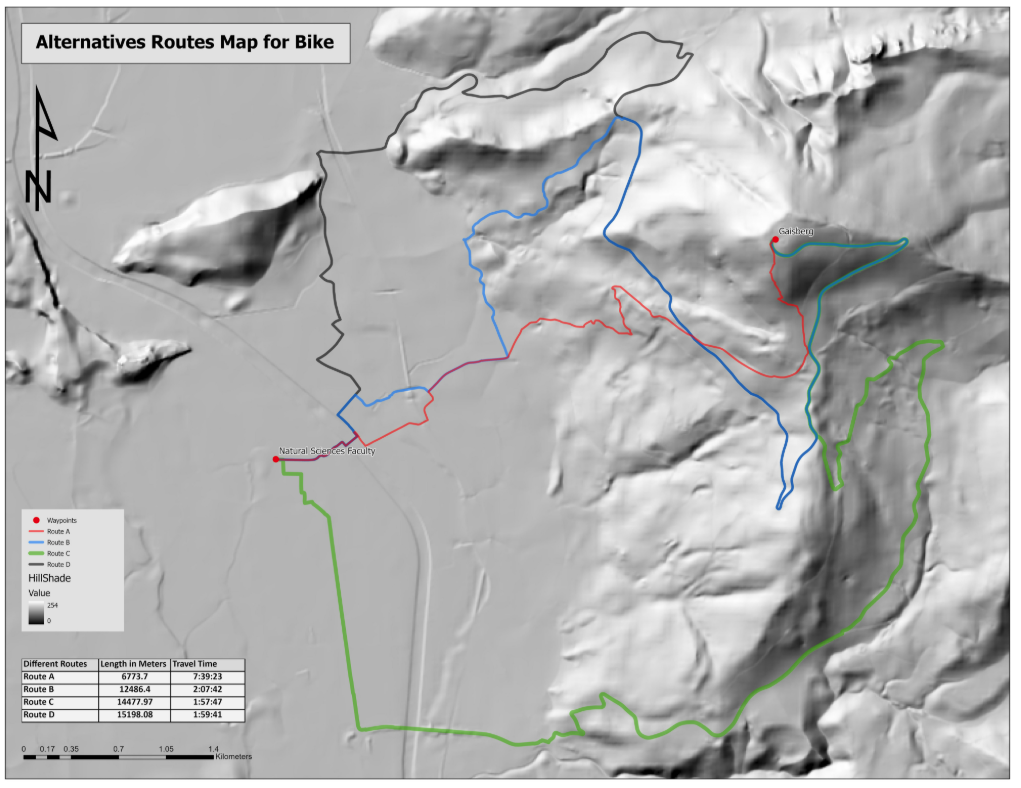
Why This Project Matters
As cities move toward sustainable and smart transportation systems, accurate bike routing plays a crucial role in:
- Promoting eco-friendly mobility
- Enhancing urban livability
- Supporting data-driven transport planning
- Improving cyclist safety and accessibility
Spatial Nexus delivers intelligent geospatial solutions that bridge the gap between real-world conditions and digital mapping systems.
Looking to Build Smart Mobility GIS Solutions?
We help organizations design and implement advanced geospatial systems for transportation, infrastructure, and urban planning.
Contact Spatial Nexus Geospatial Consultancy to develop your next GIS-driven solution.