

Wildfire Burn Severity Assessment Using Remote Sensing Analysis
Project Overview
Monitoring wildfire impact is critical for environmental management, ecological recovery, and risk mitigation. In this project, Spatial Nexus conducted an advanced remote sensing analysis using Sentinel-2 satellite imagery to assess wildfire burn severity and post-fire vegetation recovery.
By leveraging Normalized Burn Ratio (NBR) and delta NBR (dNBR) techniques, we developed a data-driven framework to quantify damage and support rehabilitation planning and environmental decision-making.
The Challenge
Wildfire-affected regions require rapid and accurate assessment to guide recovery efforts. However, traditional methods face several limitations:
- Delayed ground-based damage assessment
- Lack of scalable monitoring over large geographic areas
- Difficulty in quantifying burn severity consistently
- Limited visibility into vegetation recovery over time
These challenges create gaps in timely response, ecological planning, and resource allocation.
Our Solution
Spatial Nexus implemented a multi-temporal satellite analysis workflow using Sentinel-2 data to evaluate wildfire impact and recovery:
- Processed high-resolution Sentinel-2 imagery for pre- and post-fire analysis
- Generated false-color composites to assess vegetation health
- Normalized Burn Ratio (NBR) for burn detection
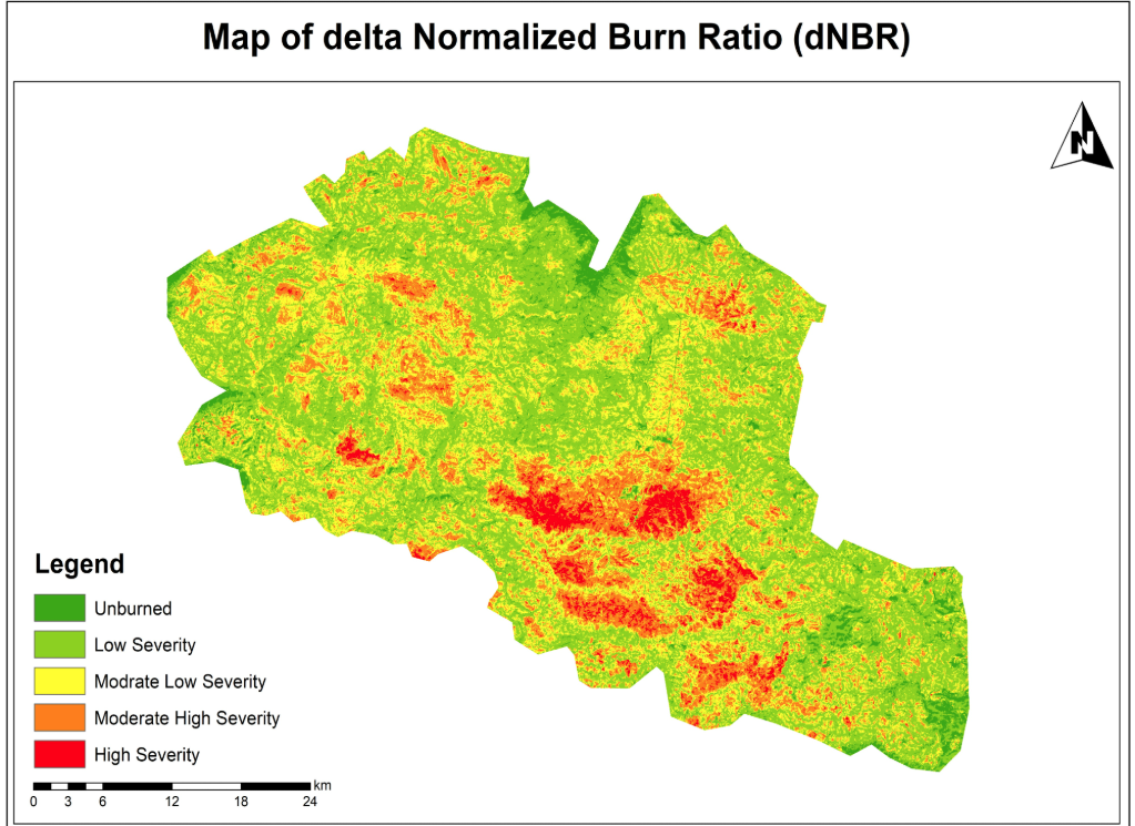
- Delta NBR (dNBR) for burn severity classification
This approach enabled accurate, scalable, and repeatable wildfire impact assessment.
The Impact
The analysis delivered critical insights for environmental monitoring and recovery planning:
- Identified high, moderate, and low burn severity zones
- Enabled data-driven rehabilitation and reforestation strategies
- Tracked vegetation recovery trends over time
- Supported decision-making for government and environmental agencies
- Demonstrated the power of remote sensing in disaster management
Technologies & Tools Used
- Sentinel-2 Satellite Imagery – High-resolution Earth observation data
- GIS Platforms – Spatial analysis and mapping
- Google Earth – Visualization and validation
- Remote Sensing Techniques – NBR & dNBR modeling
Skills & Capabilities Demonstrated
- Remote Sensing Analysis
- GIS & Spatial Data Processing
- Image Classification & Interpretation
- Georeferencing
- Environmental & Disaster Analysis
Key Highlights
- Multi-temporal wildfire analysis
- Accurate burn severity classification using dNBR
- Vegetation recovery monitoring
- Scalable environmental assessment approach
- Applicable to global wildfire-prone regions
Why This Project Matters
With increasing wildfire incidents worldwide, geospatial technologies play a crucial role in:
- Rapid damage assessment and response
- Efficient ecosystem restoration planning
- Long-term environmental monitoring
- Supporting climate resilience strategies
Spatial Nexus delivers advanced geospatial intelligence solutions that transform satellite data into actionable insights for governments and environmental organizations.
Looking to Monitor Environmental Risks Using GIS?
We help organizations leverage remote sensing and GIS technologies for disaster management, environmental monitoring, and sustainable planning.
Contact Spatial Nexus Geospatial Consultancy to develop your next geospatial solution.