Scientific GIS Solutions for Tracking and Adapting to a Changing Climate
Addressing environmental challenges and climate change demands innovative, data-driven solutions. Our GIS-RS based Environmental Monitoring & Climate Change services provide real-time insights into ecological shifts, weather anomalies, and carbon footprints. With advanced satellite imagery and remote sensing tools, we map critical environmental indicators such as temperature variation, deforestation, and pollution patterns allowing organizations to plan sustainable actions. Our solutions empower governments, environmental agencies, and private sectors to monitor climate risks, predict natural hazards, and implement strategic mitigation. We specialize in tracking land surface temperature, monitoring carbon emissions, and modeling climate vulnerabilities to support long-term resilience and policy decisions. Whether it's flood mapping or urban heat analysis, our tools transform complex data into actionable environmental intelligence. By aligning technology with sustainability, we help stakeholders tackle climate change more effectively and foster eco-conscious development.
What We Offer in Environmental Monitoring & Climate Change
We offer climate-focused GIS-RS tools that include risk mapping, emission monitoring, and temperature analysis to support sustainability, compliance, and informed environmental policy decisions.

ClimateShield GIS-RS
We deliver GIS-RS based climate risk tools that map extreme weather zones floods, droughts, and storms helping planners and responders take proactive, data-backed action.

Carbon Emission Tracking
We track carbon emissions using GIS-RS to monitor deforestation, traffic, and industrial hotspots helping clients meet environmental goals and regulations.

Land Surface Temperature (LST) Mapping
Our LST maps visualize urban heat patterns, detect warming trends, and guide climate adaptation strategies for cities and vulnerable ecosystems.
Environmental Monitoring & Climate Change Mapping Development Services
Our Environmental Monitoring & Climate Change Mapping Development Services offer comprehensive, tech-driven solutions to understand and address the Earth's rapidly changing climate. Using high-resolution satellite imagery, remote sensing, and spatial analytics, we develop GIS-RS platforms that track key environmental metrics like air quality, temperature shifts, and deforestation rates. Our custom-built tools help identify climate risks, visualize emission hotspots, and monitor environmental performance in real time. These applications support climate research, environmental compliance, and public policy planning. Whether you're a governmental agency, research institution, or sustainability-driven enterprise, our solutions empower you to monitor ecosystems and predict climate impacts. We integrate real-time weather feeds, land use data, and historical trends into intuitive GIS-RS dashboards, giving you a complete picture of climate variability. With our services, clients can better strategize for climate resilience, comply with green regulations, and promote sustainable development for a healthier planet.

Various Detailed in Environmental Monitoring & Climate Change
Our GIS-RS climate tools provide real-time mapping of weather risks, emission sources, and heat islands to support sustainable environmental planning and proactive climate adaptation strategies.

ClimateShield GIS – Flood, Drought, and Extreme Weather Risk Mapping.
Climate Shield GIS-RS is a dynamic mapping solution designed to assess climate risks like floods, droughts, and extreme weather. Using satellite data, historical weather records, and predictive models, it identifies vulnerable zones and future risk areas. These maps help agencies implement early warning systems, prepare emergency responses, and plan infrastructure with climate resilience in mind. Our tool supports proactive planning by turning complex meteorological data into easy-to-understand visual formats. It’s essential for disaster management, agriculture, and long-term urban planning.
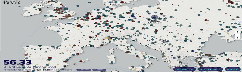
Carbon Emission Tracking – Monitoring Industrial Emissions and Deforestation.
Our Carbon Emission Tracking solution uses GIS to monitor CO₂ hotspots such as industrial areas, transport corridors, and deforested zones. We combine satellite imagery with ground data to provide detailed emissions maps that support regulatory compliance and climate reporting. This system helps governments and corporations monitor carbon levels, analyze trends, and set reduction targets. It's ideal for environmental audits, carbon trading, and ESG compliance. With visualized emissions data, decision-makers can take timely action toward decarbonization goals.
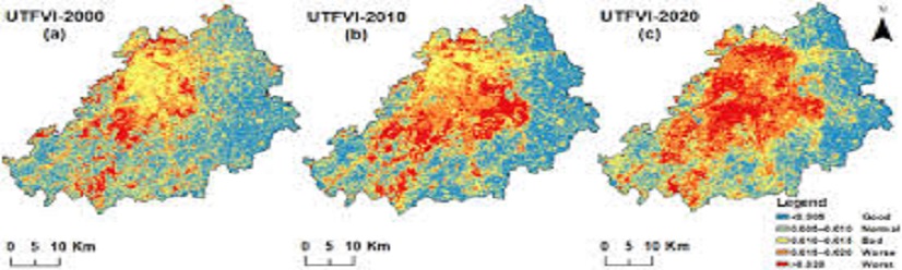
Land Surface Temperature (LST) Mapping –Analyzing Urban Heat Islands.
LST Mapping identifies and analyzes urban heat islands and rising surface temperatures across regions. Using thermal satellite data, our GIS-RS solution highlights areas most affected by climate-induced heating, aiding city planners in making cooling strategies like tree planting and reflective infrastructure. It supports urban planning, climate resilience, and environmental justice efforts. LST insights can influence green building design, heat action plans, and energy-efficient zoning, helping cities adapt to a warming climate while improving community well-being.
Geospatial Data Used in Various Industries
To increase high levels of productivity, Spatial Nexus provides Point Cloud Classification services for various industries.