Data-Driven Strategies for Sustainable Resource Optimization
Efficient management of natural resources is vital for sustainable development, environmental protection, and future resilience. Our GIS-RS based solutions provide in-depth spatial analysis and mapping tools to monitor, evaluate, and manage forests, water bodies, and biodiversity. We use high-resolution satellite imagery, remote sensing, and data modeling to support decision-makers in understanding land use, ecosystem health, and resource distribution. Our tools help detect deforestation, monitor watershed conditions, and map critical habitats, ensuring informed environmental stewardship. These GIS-RS solutions are designed for government agencies, conservation organizations, and private entities aiming to meet regulatory standards and conservation goals. Whether it's managing forest regeneration, protecting water sources, or mapping species habitats, we deliver actionable intelligence for long-term sustainability. Our goal is to help stakeholders optimize the use of natural resources while maintaining ecological balance and minimizing environmental degradation through smart, data-driven planning and real-time monitoring.
What We Offer in Natural Resource Management
We provide tailored GIS-RS tools for forest analysis, water resource planning, and habitat mapping, empowering sustainable resource use, ecosystem protection, and informed environmental management decisions.
Forest Cover Analysis
We use satellite imagery to detect deforestation and monitor afforestation progress enabling sustainable forest planning and carbon stock estimation.
Water Resource GIS-RS
Our GIS-RS tools map water bodies, model watersheds, and support efficient planning of surface water, groundwater, and irrigation systems.
Biodiversity & Habitat Mapping
We map ecosystems and wildlife habitats to help identify sensitive zones, conserve biodiversity, and plan nature-based solutions.
Natural Resource Management Mapping Development Services
Our Natural Resource Management Mapping Development Services integrate cutting-edge GIS-RS technology with environmental science to support the sustainable use of land, forests, water, and biodiversity. We create high-resolution maps and custom dashboards that track changes in natural landscapes and support conservation strategies. Our team develops tools for real-time forest monitoring, water catchment planning, and habitat assessments using remote sensing, spatial data analysis, and predictive modeling. Whether you're a government agency focused on resource allocation or an environmental NGO monitoring conservation areas, our tailored solutions simplify complex ecological data into visual insights. We offer cloud-based platforms and mobile-friendly tools for field surveys, reporting, and impact analysis. Our services ensure data accuracy, efficiency, and accessibility enabling smarter decision-making and compliance with environmental regulations. By empowering stakeholders with timely and reliable geographic intelligence, we support effective planning and management of natural resources for a more sustainable future.

Various Detailes in Natural Resource Management
Our GIS-RS services support real-time monitoring, modeling, and analysis of forests, water systems, and biodiversity to guide responsible natural resource management and promote long-term ecological balance.
Forest Cover Analysis – Tracking Deforestation and Afforestation.
Our Forest Cover Analysis service uses satellite imagery, LiDAR data, and temporal change detection to monitor forest health, track deforestation, and measure afforestation progress. We generate accurate maps that show canopy density, forest fragmentation, and land-use changes. These insights help governments and conservationists enforce protection policies, monitor carbon sequestration, and evaluate reforestation programs. Our GIS-RS solutions offer real-time updates and historical comparisons to track trends over time and predict future forest cover scenarios. This data empowers better planning for sustainable forestry and climate action.
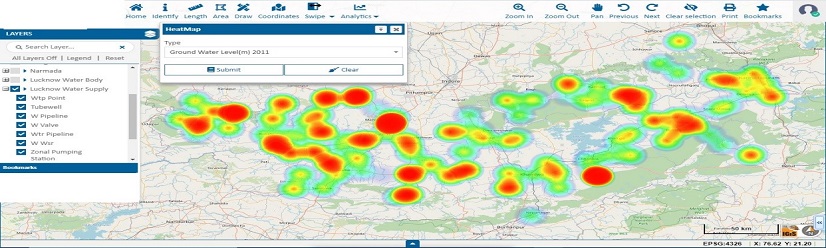
Water Resources GIS – Hydrological modeling and Watershed Management.
Our Water Resource GIS-RS solutions support integrated water management through watershed delineation, hydrological modeling, and groundwater mapping. We analyze rainfall, topography, and land use to identify recharge zones, drainage networks, and flood-prone areas. This data is crucial for managing irrigation, drinking water supply, and ecosystem restoration projects. We also provide GIS-RS dashboards that allow stakeholders to track water availability, pollution levels, and conservation progress. Our tools help planners make data-driven decisions to safeguard water resources and adapt to climate variability.
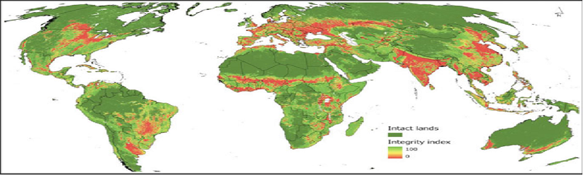
Biodiversity & Habitat Mapping – Ecosystem Health and Species Distribution.
We offer advanced biodiversity and habitat mapping to identify critical ecosystems, species distribution, and environmental hotspots. Our GIS-RS tools integrate satellite imagery, species occurrence data, and ecological indicators to evaluate ecosystem health. These maps are vital for conservation planning, protected area zoning, and biodiversity offset assessments. We support environmental impact studies, corridor identification, and restoration planning through detailed spatial analysis. With user-friendly mapping tools, our service empowers researchers, conservationists, and policymakers to maintain biodiversity while guiding sustainable development.
Geospatial Data Used in Various Industries
To increase high levels of productivity, Spatial Nexus provides Point Cloud Classification services for various industries.