Predictive Geospatial Intelligence for Proactive Risk Mitigation
Harness the power of Geographic Information Systems and Remote Sensing (GIS-RS) to proactively manage disasters and assess risks with precision. Our cutting-edge GIS-RS solutions are tailored to support emergency planning, disaster response, and risk analysis by offering real-time mapping, spatial analysis, and data visualization. From flood-prone zones to earthquake-sensitive areas, our GIS-RS technology helps identify vulnerable regions, assess infrastructure damage, and plan effective responses. With our expert-driven approach, organizations can better understand hazards, mitigate impacts, and improve resilience. We utilize satellite imagery, remote sensing data, and spatial modeling to provide timely insights and actionable intelligence. Our solutions support government agencies, NGOs, and private sectors in safeguarding lives, assets, and the environment. Whether you're planning for future risks or responding to current emergencies, our GIS services ensure smart decision-making every step of the way.
What We Offer in Disaster Management & Risk Assessment
We provide tailored GIS & RS services including disaster response mapping, risk zone analysis, and infrastructure assessments to support proactive planning, emergency response, and long-term mitigation strategies.

DisasterResponse GIS-RS
Our Disaster Response GIS-RS enables real-time situational awareness by mapping live data from affected areas. This helps emergency teams visualize hazards, optimize routes, allocate resources, and coordinate rescue efforts efficiently.

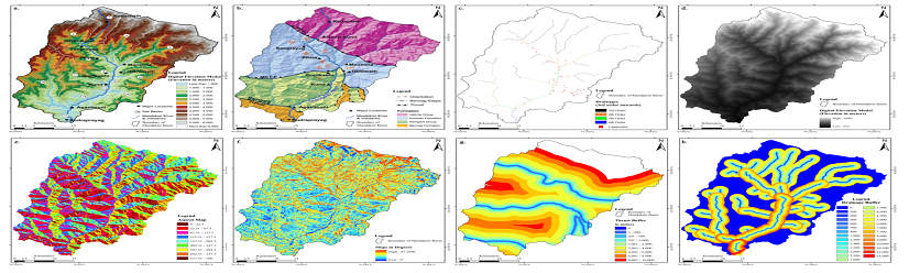
Landslide & Flood Susceptibility Mapping
We create detailed risk maps identifying areas prone to landslides and floods. Using elevation, rainfall, and soil data, we help stakeholders anticipate threats and implement early warning systems for better safety.

Earthquake Damage Assessment
Post-quake, our GIS-RS tools assess structural damage using satellite imagery and ground data. These insights help decision-makers prioritize response actions and plan for restoration with minimal downtime.
Disaster Management & Risk Assessment Mapping Development Services
Our Disaster Management & Risk Assessment Mapping Development Services combine GIS-RS, satellite imagery, and predictive modeling to create robust tools for emergency preparedness and risk mitigation. We specialize in designing custom GIS applications that provide real-time data visualization and location intelligence for better disaster planning. Whether it's flood forecasting, landslide hazard mapping, or post-disaster damage assessment, our services empower local governments, humanitarian agencies, and businesses to act quickly and effectively. We integrate high-resolution remote sensing, IoT data, and field observations into user-friendly dashboards that support timely decisions. Each solution is designed with your goals in mind, whether you need early warning systems, evacuation planning tools, or infrastructure vulnerability reports. Our development team ensures that every mapping tool is scalable, responsive, and built for crisis resilience. By transforming complex data into actionable insights, we help reduce risks, save lives, and strengthen community preparedness.

Various Detailed in Disaster Management & Risk Assessment
Our GIS-RS based disaster solutions include real-time monitoring, predictive hazard modeling, and damage evaluation tools to ensure faster response, improved planning, and minimized losses during natural or man-made disasters.
DisasterResponse GIS – Real-Time Emergency Mapping.
-RSWe deliver real-time emergency mapping solutions that empower disaster response teams with up-to-date data and actionable insights. Using dynamic GIS-RS platforms, we map affected regions instantly, highlighting damage zones, safe evacuation routes, and resource locations. Our system helps improve coordination across emergency units, facilitating faster rescue and relief operations. These tools are essential during floods, earthquakes, or wildfires where every minute matters. By integrating satellite feeds and field inputs, our GIS-RS ensures timely, data-driven decisions that protect lives and infrastructure.
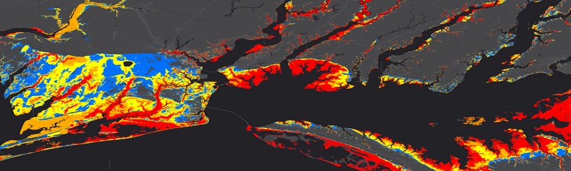
Landslide & Flood Susceptibility Mapping – Identifying high-risk zones.
We use advanced GIS-RS modeling to identify areas at high risk of landslides and floods. By analyzing factors like rainfall, terrain slope, land cover, and hydrology, we create detailed susceptibility maps that support early warning systems and land-use planning. These maps help authorities implement zoning regulations, build resilient infrastructure, and plan safe evacuation routes. Our solutions are tailored to local environments, ensuring that risk maps are not only accurate but also actionable. This proactive approach significantly reduces the impact of natural hazards.
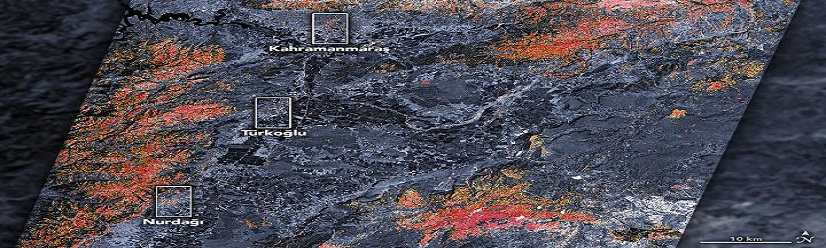
Earthquake Damage Assessment – Satellite-Based Infrastructure Analysis.
Our earthquake damage assessment solutions leverage satellite imagery, drone footage, and spatial data to evaluate structural damage after seismic events. GIS-RS technology helps rapidly identify collapsed structures, blocked roads, and vulnerable infrastructure. This analysis allows emergency teams and policymakers to allocate resources strategically and prioritize restoration efforts. With high-resolution post-event imagery, we provide timely reports that aid in insurance claims, government response, and long-term rebuilding plans. Our accurate damage assessment improves safety, speeds up recovery, and minimizes economic loss.
Geospatial Data Used in Various Industries
To increase high levels of productivity, Spatial Nexus provides Point Cloud Classification services for various industries.