

Client & Workforce Distribution Mapping Using GIS (Switzerland)
Project Overview
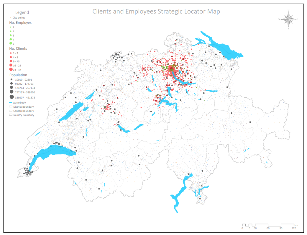
Understanding the spatial relationship between clients and workforce is critical for operational efficiency and service optimization. In this project, Spatial Nexus developed a comprehensive GIS-based strategy map for a cleaning services company in Switzerland, enabling clear visualization of client locations and employee distribution.
The objective was to transform raw operational data into an intelligent geospatial framework that supports data-driven decision-making and service area optimization.
The Challenge
The client faced limitations in understanding how their workforce and customer base were geographically distributed:
- Lack of visibility into client concentration areas
- Inefficient allocation of employees across service regions
- Difficulty identifying high-demand clusters
- Limited insights for expanding or optimizing service coverage
These challenges restricted the company’s ability to scale efficiently and maximize resource utilization.
Our Solution
Spatial Nexus implemented a GIS-driven spatial analysis and visualization approach to map and interpret the organization’s operational data:
- Collected and structured client and employee location data
- Client locations represented in red
- Employee locations represented in blue
- Cluster circles sized proportionally to reflect density and distribution
- Delivered a visually intuitive and decision-ready GIS map
This solution enabled the organization to clearly understand its operational footprint and improve service planning.
The Impact
The project delivered actionable insights that significantly enhanced operational strategy:
- Improved service area planning and workforce allocation
- Identified high-demand clusters for targeted expansion
- Reduced inefficiencies in employee deployment
- Enhanced decision-making through clear geospatial visualization
- Supported scalable growth with data-driven insights
Technologies & Tools Used
- ArcGIS – Spatial analysis and mapping
- QGIS – Data processing and visualization
- GIS Infographic Tools – Cluster-based visualization
- Microsoft Office – Data structuring and reporting
Skills & Capabilities Demonstrated
- GIS Spatial Analysis
- Geospatial Data Visualization
- Cluster Mapping & Density Analysis
- Image Processing & Cartography
- Location Intelligence & Business Analytics
Key Highlights
- Cluster-based visualization of clients and workforce
- Color-coded mapping for intuitive interpretation
- Scalable solution for operational optimization
- Data-driven approach to service planning
- Real-world business intelligence powered by GIS
Why This Project Matters
For service-based organizations, understanding where clients and resources are located is essential for efficiency and growth. This project demonstrates how GIS can transform operational data into strategic insights, enabling businesses to:
- Optimize workforce distribution
- Improve service coverage
- Enhance customer satisfaction
- Make informed expansion decisions
Spatial Nexus specializes in delivering location intelligence solutions that bridge the gap between data and strategy.
Looking to Optimize Your Operations with GIS?
We help organizations unlock the power of geospatial data to improve efficiency, planning, and decision-making.
Contact Spatial Nexus Geospatial Consultancy to build your next data-driven solution.