Top GIS &RS Solutions for Remote Sensing & Satellite Image Analysis
Remote Sensing and Satellite Image Analysis offer powerful tools to extract valuable insights from Earth’s surface using aerial and satellite data. Our GIS-RS solutions combine advanced imagery processing with spatial intelligence to support land monitoring, resource management, and environmental assessments. We specialize in analyzing multispectral and hyperspectral imagery, detecting landscape changes over time, and processing LiDAR data for accurate 3D modeling. With remote sensing, users can monitor deforestation, urban expansion, crop health, and natural disasters with high precision. Our solutions are used across sectors like agriculture, forestry, urban planning, mining, and disaster management. By integrating satellite imagery with GIS technology, we deliver real-time, location-based data that improves planning and decision-making. From raw image interpretation to detailed spatial analysis, we help organizations gain a clear understanding of ground realities without physical surveys—saving time, reducing costs, and enhancing environmental monitoring capabilities with unmatched clarity and consistency.
What We Offer in Remote Sensing & Satellite Image Analysis

Multispectral & Hyperspectral Analysis

Change Detection Analysis

LiDAR Data Processing
Remote Sensing & Satellite Image Analysis Services
Our Remote Sensing & Satellite Image Analysis Services provide a comprehensive suite of solutions for analyzing Earth’s surface using advanced image processing techniques. We harness the power of satellite, aerial, and drone imagery to deliver critical insights for environmental monitoring, infrastructure planning, agriculture, forestry, and disaster response. By utilizing multispectral and hyperspectral sensors, we analyze surface properties, vegetation indices, water quality, and more. Our change detection tools reveal long-term land transformations such as deforestation, urban sprawl, and erosion. We also process LiDAR point clouds to create high-resolution elevation models and 3D landscape representations. These services support clients in project planning, compliance reporting, and strategic decision-making. Our solutions offer precise, scalable, and cost-effective alternatives to ground-based surveys. From raw image processing to thematic mapping, we ensure actionable data is accessible through user-friendly GIS-RS dashboards transforming satellite imagery into clear, impactful intelligence that drives sustainable development and resource optimization.

Various Detailed in Remote Sensing & Satellite Image Analysis
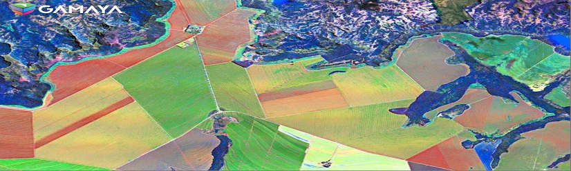
Multispectral & Hyperspectral Analysis – Extracting Data From Spectral Bands.
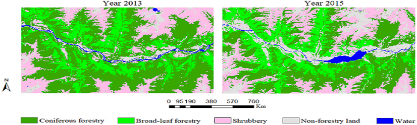
Change Detection Analysis – Monitoring Land Use and Environmental Changes.
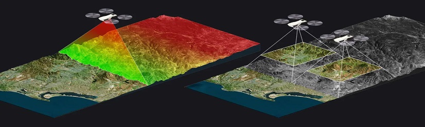
LiDAR Data Processing – 3D Terrain Modeling and Vegetation Analysis.
Geospatial Data Used in Various Industries
To increase high levels of productivity, Spatial Nexus provides Point Cloud Classification services for various industries.