Optimizing Green Energy Infrastructure through Spatial Decision Support System
Renewable energy development requires precise spatial analysis to ensure efficient site selection, planning, and environmental compliance. Our GIS-RS based solutions empower organizations to explore clean energy opportunities by mapping solar, wind, and sustainable infrastructure potential. Using satellite imagery, terrain modeling, and climate datasets, we identify optimal locations for renewable energy projects while minimizing ecological impact. Our tools support environmental planners, energy developers, and government bodies in aligning projects with sustainability goals. From evaluating solar irradiance and wind patterns to designing green urban spaces, we help integrate renewable strategies into land use planning. Whether it’s a large-scale solar farm or a local green infrastructure initiative, our GIS-RS solutions offer actionable insights, enhance project viability, and reduce risks. With data-driven mapping and spatial analytics, we contribute to a cleaner, more resilient future. Trust our services to support informed decisions, optimize renewable energy investments, and ensure sustainable development aligned with global climate objectives.
What We Offer in Renewable Energy & Sustainability
We offer GIS-RS based tools for solar and wind site assessment, environmental impact mapping, and green infrastructure planning to support sustainable energy development and climate-smart urban growth.
Solar Potential Mapping
We analyze solar irradiance and land suitability to locate the best areas for solar energy projects and photovoltaic installations.

Wind Energy GIS-RS
Our GIS-RS tools evaluate wind speed, terrain, and accessibility to help plan efficient and productive wind farms.

Green Infrastructure Planning
We use spatial planning to design sustainable urban systems including green roofs, urban forests, and eco-corridors.
Renewable Energy & Sustainability Mapping Development Services
Our Renewable Energy & Sustainability Mapping Services offer cutting-edge GIS-RS solutions tailored to the growing demands of clean energy development and eco-friendly urban planning. We use advanced spatial analysis to identify high-potential sites for solar and wind energy installations, considering terrain, climate data, proximity to grid networks, and environmental sensitivity. Our mapping services reduce project risk, improve ROI, and support compliance with sustainability regulations. For solar energy, we deliver irradiance maps and rooftop feasibility assessments. For wind energy, we model wind flow, elevation, and land use to optimize turbine placement. In green infrastructure, we provide urban planners with tools to design sustainable systems like permeable surfaces, green corridors, and energy-efficient layouts. Our solutions combine satellite imagery, environmental layers, and GIS-RS modeling to produce accurate, actionable insights. Whether planning small-scale green projects or utility-scale renewables, we help our clients make informed, sustainable decisions rooted in real-world geospatial data.

Various Detailed in Renewable Energy & Sustainability
Our GIS-RS services deliver spatial insights for efficient renewable energy planning supporting solar, wind, and green infrastructure initiatives through data-driven sustainability strategies and precision mapping.
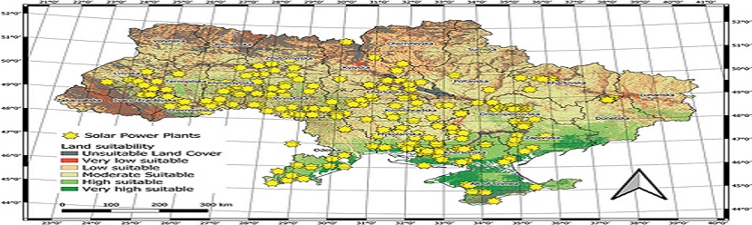
Solar Potential Mapping – Site Selection for Solar Farms.
Our Solar Potential Mapping service uses high-resolution satellite data, slope analysis, and solar radiation models to identify the most suitable locations for solar farms. We evaluate factors like land cover, aspect, shading, and grid proximity to optimize energy yield and cost-efficiency. GIS-RS tools provide feasibility maps, solar irradiance layers, and detailed suitability scores, empowering planners and investors to make informed decisions. This service reduces land acquisition risks and accelerates project timelines while promoting sustainable solar development with minimal environmental disruption.
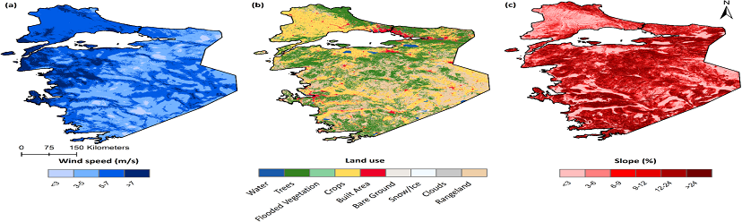
Wind Energy GIS – Analyzing Terrain and Wind Patterns for Wind Farms.
Our Wind Energy GIS-RS services evaluate wind speed, direction, and terrain features to pinpoint ideal locations for wind turbine installation. By integrating digital elevation models (DEMs), land cover data, and historical wind datasets, we help optimize turbine layout and energy capture. We also assess access routes, environmental impacts, and proximity to transmission lines. These insights enable energy developers to improve performance forecasts, reduce costs, and enhance regulatory compliance. With our GIS-RS analysis, wind farm planning becomes more precise, sustainable, and investment-ready.
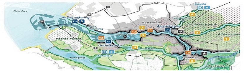
Green Infrastructure Planning – Urban Sustainability Projects with GIS-RS.
Green Infrastructure Planning integrates GIS-RS with urban design to develop resilient and eco-friendly cities. We analyze spatial data to design solutions such as rain gardens, urban forests, green roofs, and permeable pavements. Our GIS-RS tools help locate underutilized urban spaces, assess environmental benefits, and prioritize sustainability investments. This service supports local governments and planners in reducing urban heat islands, managing stormwater, and improving air quality. By aligning green infrastructure with urban growth, we promote healthier, more sustainable communities and resilient cityscapes.
Geospatial Data Used in Various Industries
To increase high levels of productivity, Spatial Nexus provides Point Cloud Classification services for various industries.