How does your city know where to put a new hospital? Or how does a wildfire management team decide which neighborhoods to evacuate first?
The answer, almost always, is GIS - Geographic Information Systems.
If you've never heard the term, you're not alone. But here's the thing: GIS is quietly running the world around you. From the apps on your phone to the maps your government uses, this technology is shaping decisions that affect your daily life. This guide breaks it all down — no technical background required.
What Is GIS, Really?
At its core, GIS is a system that captures, stores, analyzes, and displays geographic data. Think of it as a supercharged digital map - one that doesn't just show you where things are, but why they're there and what it means.
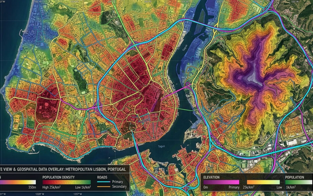
A traditional paper map shows roads and cities. A GIS map can layer on top of that:
- Population density
- Elevation and terrain
- Rainfall patterns
- Crime statistics
- Utility infrastructure
Each layer tells a different story. Stack them together, and you start seeing patterns that would be invisible otherwise.
Here's a simple analogy. Imagine placing several transparent sheets on top of each other, each one showing a different type of data about the same city. That's essentially what GIS does digitally, dynamically, and at massive scale.
How GIS Works: The Building Blocks
GIS mapping relies on three core components working together:
1. Spatial Data
This is the "where" coordinates, shapes, boundaries. It comes in two formats:
- Vector data points, lines, and polygons (think: a dot for a city, a line for a road, a polygon for a country's border)
- Raster data grid-based images like satellite photos or elevation models
2. Attribute Data
This is the "what" the information attached to a location. A point on a map might represent a school, but the attribute data tells you its name, number of students, year it was built, and test scores.
3. GIS Software
Programs like ArcGIS, QGIS, and Google Earth Engine pull everything together. They let analysts run queries, build visualizations, and generate reports. Some are free and open-source; others cost thousands of dollars per year for enterprise use.
Why GIS Matters More Than You Think
Most people think GIS is just about maps. It's not. It's about decision-making.
Take urban planning. In 2010, researchers used GIS spatial data to map food deserts across Chicago neighborhoods where residents had no access to fresh produce within walking distance. The findings directly influenced city policy and led to new grocery store incentives in underserved areas.
That's the power of GIS in action. It turns raw geographic data into insight and insight into action.
According to a report by MarketsandMarkets, the global GIS market was valued at over $9.4 billion in 2024 and is projected to grow significantly through the 2034 Forecast Market Sizes approximately $29.6 billion, driven by demand in infrastructure, agriculture, and defense sectors.
Real-World GIS Applications Across Industries
GIS software isn't limited to academia or government. It's everywhere.
Environmental Management
Conservationists use GIS to track deforestation, monitor endangered species habitats, and model the spread of wildfires. During the 2020 Australian bushfires, GIS tools helped emergency teams visualize fire paths in real time and coordinate evacuations.
Healthcare and Epidemiology
This one hit close to home during the COVID-19 pandemic. Public health teams used GIS mapping to track case clusters, identify vulnerable populations, and allocate hospital resources. The Johns Hopkins COVID dashboard the one most of us checked daily was built on GIS principles.
Agriculture
Precision farming uses GIS to analyze soil quality, crop yields, and irrigation needs field by field. Farmers can apply fertilizer only where it's needed, cutting costs and reducing environmental runoff.
Transportation and Logistics
Every time a delivery company optimizes a driver's route, there's GIS involved. Cities use it to time traffic lights, plan public transit routes, and identify accident-prone intersections.
Getting Started with GIS: What You Actually Need
You don't need a geography degree to start learning GIS. Here's the real talk.
Start with free tools. QGIS is completely open-source and surprisingly powerful. It has a steeper learning curve than Google Maps, but there are dozens of free tutorials on YouTube and dedicated communities on Reddit.
Understand the data first. Before touching software, learn what spatial data is, where to find it (try data.gov or OpenStreetMap), and how it's structured. This foundation will save you hours of frustration later.
Pick a use case you care about. The fastest way to learn GIS is to map something that interests you, your neighborhood, your city's bike lanes, restaurant density in your area. Curiosity beats obligation every time.
Most people think GIS is only for professionals. Actually, tools like Google Maps, Uber, and Zillow are built on the same spatial data principles. You've already been using GIS you just didn't know what to call it.
Frequently Asked Questions About GIS
What does GIS stand for?
GIS stands for Geographic Information System. It refers to any system that creates, manages, analyzes, and maps spatial or geographic data. The term covers both the software tools and the broader methodology of geographic analysis.
Is GIS the same as GPS?
Not exactly. GPS (Global Positioning System) is a satellite-based technology that pinpoints your location. GIS uses that location data (and much more) to analyze and visualize patterns. GPS feeds data into GIS; they work together but serve different purposes.
What skills do I need to learn GIS?
You don't need to be a programmer to get started. Basic data literacy helps understanding spreadsheets and how data is structured. As you advance, skills in Python or SQL become valuable for automating GIS workflows. But at the beginner level, clicking through QGIS with a tutorial is totally doable.
How long does it take to learn GIS?
For basic competency loading data, creating maps, running simple analyses expect 2–4 weeks of focused learning. Professional-level GIS work, including spatial statistics and custom scripting, typically takes 6–12 months of hands-on experience.
What industries hire GIS professionals?
Government agencies, environmental consulting firms, urban planners, tech companies, logistics providers, the military, and healthcare organizations all hire GIS analysts and specialists. It's a growing field with strong job prospects.
Why GIS Is Worth Understanding
Let's bring it home. Here are the three things to walk away with:
- GIS is a system for connecting data to place it's not just mapping, it's spatial reasoning at scale.
- It's used across virtually every industry, from healthcare to agriculture to disaster response.
- You can start learning it today, for free, with tools like QGIS and public datasets from government portals.
Geographic Information Systems aren't some niche tech buzzword. They're a foundational tool for understanding our world and increasingly, for navigating it.
Whether you're a student, a professional curious about data, or just someone who wants to understand how cities make decisions, GIS is worth your time.
Ready to explore GIS? Download QGIS for free, load an OpenStreetMap dataset of your city, and build your first map this weekend. You might be surprised how quickly it clicks.