What Is Remote Sensing? How Satellites See the Earth
Think about the last time you checked a weather forecast. Or watched a news report about melting glaciers. Or used Google Maps in satellite view.
None of that exists without remote sensing.
It's one of those technologies that's everywhere and almost nobody talks about it. Remote sensing is how we watch our planet from above, measure changes we can't see with the naked eye, and make decisions that affect billions of people. And yet most people couldn't define it if you asked them.
That changes today. Here's your plain-English guide to remote sensing, how it works, and why it matters more than you probably realize.
What Is Remote Sensing?
Remote sensing is the science of collecting information about an object or area without physically touching it. In practice, this almost always means using satellites, aircraft, or drones to observe the Earth's surface from a distance.
The "remote" part is key. You're not standing in a field measuring soil moisture with a probe you're doing it from hundreds of kilometers above, using sensors that detect energy reflected or emitted from the Earth's surface.
Here's a simple way to think about it: your eyes are remote sensors. They detect light reflected off objects without touching them. A satellite works on the same principle just at a vastly greater scale, picking up wavelengths of energy your eyes can't even see.
Remote sensing is a core component of modern Earth observation, and it feeds data into GIS systems, climate models, agricultural platforms, and disaster response tools around the world.
How Remote Sensing Works: The Science Behind the Imagery
To understand remote sensing, you need to know one thing: everything emits or reflects energy.
The sun radiates energy across the electromagnetic spectrum from gamma rays all the way to radio waves. When that energy hits the Earth, some is absorbed, some is transmitted, and some is reflected back upward. Sensors on satellites detect that reflected or emitted energy and record it as data.
Active vs. Passive Remote Sensing
There are two main types, and the difference is straightforward:
- Passive remote sensing the sensor detects natural energy, usually reflected sunlight. Standard optical satellite imagery is passive. It works great in daylight but struggles through clouds or at night.
- Active remote sensing the sensor emits its own energy pulse and measures what bounces back. Radar and LiDAR are active systems. They work day or night, and can even penetrate cloud cover and forest canopies.
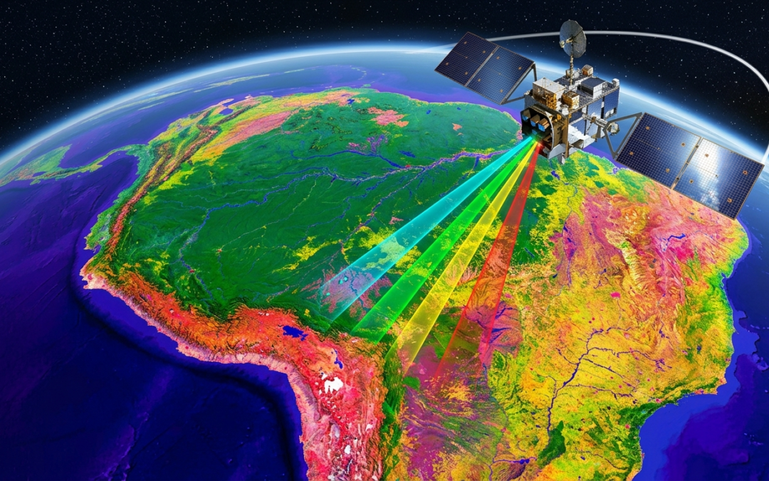
Spectral Bands: Seeing Beyond Visible Light
This is where it gets interesting. Humans see in three color bands red, green, blue. Satellites can see in dozens.
Infrared bands reveal vegetation health healthy plants reflect near-infrared strongly, so a lush field looks bright on an infrared image while a drought-stressed one looks dull. Thermal infrared detects heat, useful for spotting wildfires, tracking urban heat islands, or monitoring industrial activity. Microwave bands penetrate clouds and measure soil moisture or ice thickness.
The ability to see across the electromagnetic spectrum is what makes remote sensing so powerful. You're not just taking a photograph. You're reading the planet's vital signs.
The Satellites Doing the Work
Not all satellites are the same. Different missions are built for different purposes.
Landsat - The Long-Haul Workhorse
NASA and USGS have operated the Landsat program since 1972 the longest continuous record of Earth's surface from space. Landsat imagery has been used to document deforestation in the Amazon, track urban sprawl, and monitor crop changes across entire continents. It's free to access and has been downloaded millions of times by researchers worldwide.
Sentinel - Europe's Earth Watchers
The European Space Agency's Sentinel satellites are workhorses of the Copernicus Earth observation program. Sentinel-2 captures high-resolution optical imagery every 5 days. Sentinel-1 uses radar, making it invaluable for flood mapping and ice monitoring regardless of weather conditions.
Commercial Satellites - The New Players
Companies like Planet Labs, Maxar, and Airbus Defence & Space now operate dense constellations of small satellites. Planet's fleet can image every point on Earth every single day. That daily cadence is transforming industries from commodity trading (tracking cargo ships and crop yields) to national security.
Remote Sensing Applications: Where It Shows Up in Real Life
Remote sensing isn't an academic curiosity. It's operational, and it touches your life in ways you probably don't notice.
Disaster Response and Emergency Management
When a hurricane makes landfall or a wildfire breaks out, remote sensing data is often the first comprehensive picture emergency managers get. Satellites can assess damage across hundreds of square kilometers in hours before ground teams can safely access the area.
After the 2023 earthquake in Turkey and Syria, satellite imagery from Maxar and the Copernicus Emergency Management Service was used to map collapsed buildings and prioritize search-and-rescue operations within days of the disaster.
Agriculture and Food Security
Farmers and governments use satellite imagery to monitor crop health at a field-by-field level. The Normalized Difference Vegetation Index (NDVI) calculated from red and near-infrared bands gives a precise reading of how green and healthy vegetation is. The UN's Food and Agriculture Organization uses this data to forecast harvests and flag food security risks months in advance.
Climate Change Monitoring
Remote sensing is one of our primary tools for tracking climate change. Satellites measure Arctic sea ice extent, glacier retreat, sea surface temperatures, and atmospheric CO₂ concentrations. Without this data, our climate models would be flying blind.
NASA's GRACE mission measured changes in Earth's gravitational field caused by shifting water mass and revealed alarming rates of groundwater depletion in aquifers across India, the Middle East, and the American Southwest.
Urban Planning and Infrastructure
City planners use satellite imagery and LiDAR data to map buildings, roads, green spaces, and underground utilities. Heat mapping from thermal sensors helps identify neighborhoods most vulnerable to extreme heat a growing concern as cities warm faster than surrounding rural areas.
Frequently Asked Questions About Remote Sensing
What's the difference between remote sensing and GIS?
Remote sensing collects the data it's the observation layer. GIS analyzes and visualizes that data it's the analysis layer. They're deeply connected. Satellite imagery is one of the most common data inputs into GIS systems. Think of remote sensing as the camera and GIS as the darkroom.
How accurate is satellite imagery?
It depends on the satellite. Commercial satellites like Maxar's WorldView-3 can resolve objects as small as 30 centimeters on the ground. Free public satellites like Landsat 8 have a resolution of 30 meters good for large-scale analysis but not for identifying individual buildings. Resolution has improved dramatically in the past decade.
Can anyone access satellite imagery?
Yes. Programs like Landsat (NASA/USGS), Sentinel (ESA/Copernicus), and NASA Earthdata provide free access to massive archives of satellite imagery. Google Earth Engine makes it possible to analyze petabytes of this data in a browser no downloads required.
Is remote sensing only done by satellites?
No. Aerial photography from aircraft has been used since the early 1900s. Today, drones (UAVs) are increasingly used for high-resolution, low-altitude remote sensing especially in agriculture, construction, and environmental monitoring. The principle is the same; the platform is different.
The Bigger Picture
Three things to take away from all of this:
- Remote sensing is how we see our planet at scale from crop stress in Kansas to glacier melt in Greenland, it captures what no ground team ever could.
- It's not just satellite photos it spans radar, LiDAR, thermal imaging, and hyperspectral sensors across the full electromagnetic spectrum.
- The data is increasingly accessible free programs like Landsat and Sentinel have democratized Earth observation in ways that were unimaginable 20 years ago.
Remote sensing is one of those fields that rewards curiosity. The more you learn about it, the more you see it in the weather app on your phone, in news reports about Arctic ice, in the precision farming revolution quietly reshaping how we grow food.
Want to see it for yourself? Head to earthengine.google.com and explore decades of satellite imagery for any location on Earth. Pick somewhere you know and watch it change over time. It's hard not to be hooked.