About this project
Project overview
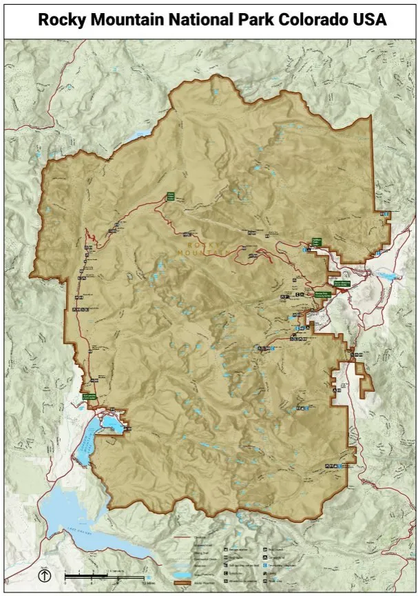
High-quality cartographic design is essential for effective communication in environmental management and tourism. In this project, Spatial Nexus replicated and enhanced maps developed by the National Park Service (NPS) using ArcGIS Pro to create a more refined, user-centric mapping solution.
The objective was to improve map readability, visual hierarchy, and spatial clarity while ensuring consistency with modern GIS cartographic standards. The enhanced maps were designed to better support park visitors, planners, and decision-makers by delivering clear and intuitive geographic insights.
- GIS cartography
- ArcGIS Pro map design
- national park mapping
- map symbology
- digital cartography
Project at a glance
- Client
- Environmental management and tourism
- Sector
- Parks and Recreation
- Location
- United States
- Software
- ArcGIS Pro, GIS Data Sources, Digital Cartography Techniques
THE CHALLENGE
What needed solving
- The original map needed clearer hierarchy between terrain, trails and facilities.
- Dense information reduced readability for visitors.
- The enhanced version had to follow modern cartographic standards while staying faithful to the original.
OBJECTIVES
What the project set out to do
- Replicate the original NPS map accurately in ArcGIS Pro.
- Improve readability, symbology and visual hierarchy.
- Make the map more intuitive for visitors, planners and decision-makers.
Methodology
Our workflow, step by step
01
Data assembly
Terrain, trail and infrastructure layers were collected and prepared in ArcGIS Pro.
02
Replication
The original layout, extent and content were reproduced as the baseline.
03
Symbology optimisation
Colours, line weights and symbols were refined to separate features clearly.
04
Labelling and hierarchy
Label placement and typography were improved so key information stands out.
05
Layout finishing
Legend, scale, north arrow and inset elements were redesigned for clarity.
Visual output
The map
Select the image to view it at full size.
Results
What the analysis delivered
- A cleaner, more readable park map with stronger visual hierarchy.
- Improved wayfinding for visitors through clearer trails and facilities.
- A professional cartographic product suitable for print and digital use.
Key highlights
Why this project stands out
- Faithful replication of an official map
- Refined symbology and labelling
- Improved visual hierarchy
- Print and digital ready
Data sources
Data used
- Terrain and elevation data
- Trail networks
- Park infrastructure and facilities
- Boundaries and reference layers
Tools and technologies
Software and methods
Deliverables
What the client received
- Enhanced park map (high resolution)
- ArcGIS Pro project and layout
- Symbology documentation
WHY IT MATTERS
Good cartography makes geographic information usable. Clearer park maps improve visitor experience and support planning and management.
FAQ
Questions about this project
Why replicate an existing map?
Replication establishes an accurate baseline, so enhancements can be measured against the original design.
What was improved?
Symbology, label placement, colour hierarchy and layout elements, focusing on readability and usability.
Which software was used?
ArcGIS Pro for cartographic design and spatial data processing.
Related projects