About this project
Project overview
Mapping postal code boundaries across metropolitan Riyadh as clean GIS and GeoJSON layers for logistics, last-mile delivery and smart city applications.
- postcode boundary mapping
- GeoJSON mapping services
- last-mile delivery GIS
- smart city geospatial data
- Riyadh GIS mapping
Project at a glance
- Client
- Logistics and smart city applications
- Sector
- Logistics
- Location
- Riyadh, Saudi Arabia
- Software
- ArcGIS Pro, QGIS, Satellite basemap, Global Mapper
THE CHALLENGE
What needed solving
- Delivery and planning teams needed postcode zones as usable GIS boundaries, not static images.
- Boundaries had to align with the street network and avoid gaps or overlaps.
- Data had to work in web maps and routing tools.
OBJECTIVES
What the project set out to do
- Create a complete postcode boundary layer for metropolitan Riyadh.
- Ensure clean topology with no gaps or overlaps.
- Deliver the layer in GIS and GeoJSON formats for web use.
Methodology
Our workflow, step by step
01
Reference collection
Postcode reference material and the street network were gathered for the metropolitan area.
02
Boundary digitising
Postcode zones were digitised along streets and natural boundaries over satellite imagery.
03
Topology checks
Rules removed gaps, overlaps and slivers between adjacent zones.
04
Attribution
Each polygon received its postcode and descriptive attributes.
05
Export and mapping
Layers were exported to GeoJSON and Shapefile and a reference map was produced.
Visual output
The map
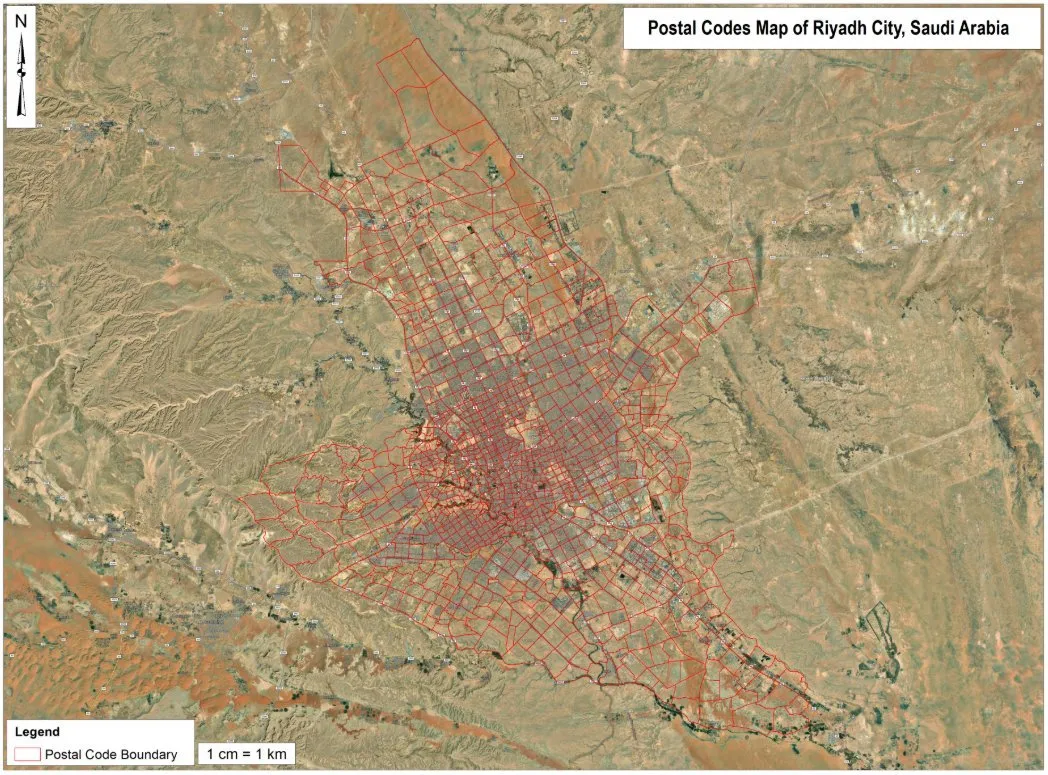
Spatial Nexus map output. Select the image to view it at full size.
Results
What the analysis delivered
- A seamless postcode boundary layer covering metropolitan Riyadh.
- Web-ready GeoJSON for interactive maps and routing platforms.
- A clear reference map showing postcode zones over imagery.
Key highlights
Why this project stands out
- City-scale boundary mapping
- Topologically clean polygons
- GeoJSON for web GIS
- Ready for logistics and routing
Data sources
Data used
- Postcode reference information
- High-resolution satellite basemap
- Road and street network
Tools and technologies
Software and methods
Deliverables
What the client received
- Postcode boundary layer (GeoJSON and Shapefile)
- Reference map (PDF and PNG)
- Attribute data dictionary
WHY IT MATTERS
Accurate postcode boundaries let logistics companies assign delivery zones, plan routes and analyse demand, and give city planners a consistent spatial reference.
FAQ
Questions about this project
What is GeoJSON?
An open, lightweight format for geographic data that works directly in web maps such as Leaflet, Mapbox and ArcGIS Online.
Can the boundaries be used for routing?
Yes. Zones can be combined with road networks to assign deliveries and plan routes.
Can you map postcodes for other cities?
Yes. The same workflow applies to any city with postcode reference information.
Related projects