About this project
Project overview
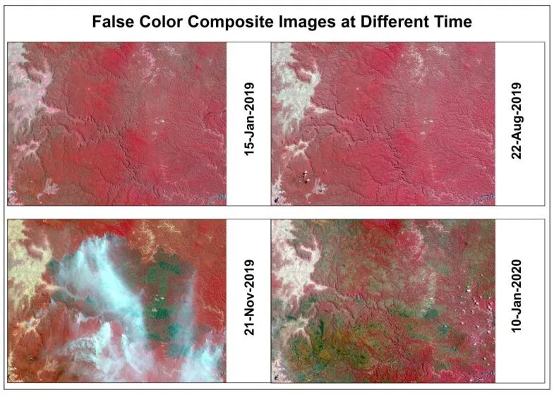
Using Google Earth Engine to compare true-colour and false-colour satellite composites across four dates and track seasonal and land-surface change.
- Google Earth Engine
- multi-temporal satellite imagery
- false color composite
- satellite time series analysis
- Earth Engine remote sensing
Project at a glance
- Client
- Environmental monitoring
- Sector
- Environment
- Service
- Google Earth Engine
- Software
- Google Earth Engine, Sentinel-2 / Landsat, QGIS, Python, ENVI
THE CHALLENGE
What needed solving
- Change between seasons is hard to see in single natural-colour images.
- Downloading and processing many scenes locally is slow.
- Cloud cover affected some dates.
OBJECTIVES
What the project set out to do
- Build comparable composites for four dates.
- Use false-colour band combinations to highlight vegetation and surface change.
- Produce clear comparison panels for reporting.
Methodology
Our workflow, step by step
01
Filtering
Imagery was filtered in Earth Engine by area, date and cloud cover.
02
Cloud masking
Cloud and shadow were masked to keep composites clean.
03
Composites
True-colour and false-colour composites were built for each date.
04
Comparison layout
Composites were arranged as dated panels for side-by-side comparison.
Visual output
The map
Spatial Nexus map output. Select the image to view it at full size.
Results
What the analysis delivered
- Four dated true-colour and false-colour panels of the same area.
- Clear visibility of vegetation and surface change between seasons.
- A reusable Earth Engine script for future dates.
Key highlights
Why this project stands out
- Cloud-based processing in Earth Engine
- Four-date comparison
- False-colour vegetation enhancement
- Reusable script
Data sources
Data used
- Sentinel-2 / Landsat imagery for January 2019, August 2019, November 2019 and January 2020
- Area of interest boundary
Tools and technologies
Software and methods
Deliverables
What the client received
- True-colour and false-colour comparison maps
- Earth Engine script
- Exported composites
WHY IT MATTERS
Multi-temporal monitoring turns satellite archives into evidence of change, supporting environmental reporting, agriculture and land management.
FAQ
Questions about this project
Why use false colour?
False-colour combinations using near-infrared make healthy vegetation appear bright red, revealing differences invisible in natural colour.
Do I need to download imagery?
No. Google Earth Engine processes the imagery in the cloud and exports only the results.
Can monitoring be automated?
Yes. Scripts can process new scenes as they become available.
Related projects