Network Analysis for Optimized Advanced Bike Routes Using GIS
About this project
Project overview
Efficient route planning is critical for sustainable mobility and smart transportation systems. In this project, Spatial Nexus developed an advanced GIS-based bike routing solution using ArcGIS Pro and OpenStreetMap (OSM) data to generate optimized and alternative cycling routes.
The objective was to enhance the accuracy, safety, and usability of bike navigation systems, particularly in complex environments such as mountainous and terrain-sensitive regions.
- GIS network analysis
- bike route optimization
- ArcGIS Pro routing
- OpenStreetMap GIS
- sustainable mobility planning
Project at a glance
- Client
- Mobility and transport planning
- Sector
- Transport
- Software
- ArcGIS Pro, ArcGIS Online, OpenStreetMap (OSM)
THE CHALLENGE
What needed solving
- Standard routing often ignores slope and terrain, which matter greatly for cyclists.
- Riders need safe alternatives, not just the shortest path.
- Routes had to be realistic, not only theoretically optimal.
OBJECTIVES
What the project set out to do
- Build a routable cycling network from OpenStreetMap data.
- Generate optimised and alternative bike routes.
- Account for terrain in route selection.
- Validate routes against real-world conditions.
Methodology
Our workflow, step by step
01
Network dataset
OpenStreetMap roads and paths were converted into a network dataset in ArcGIS Pro.
02
Cost attributes
Distance and terrain-based costs were added so routes reflect cycling effort.
03
Route solving
Optimal and alternative routes were calculated between selected origins and destinations.
04
Validation
Routes were compared with real-world conditions to confirm they are practical.
05
Sharing
Results were published via ArcGIS Online for review and visualisation.
Visual output
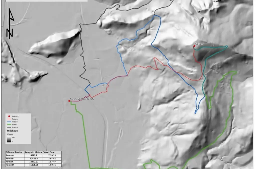
The map
Select the image to view it at full size.

Results
What the analysis delivered
- Optimised and alternative cycling routes for each journey.
- Terrain-aware routes better suited to real riding conditions.
- Outputs that support cycling infrastructure and navigation planning.
Key highlights
Why this project stands out
- ArcGIS Pro Network Analyst
- OpenStreetMap network data
- Terrain-aware routing
- Real-world route validation
Data sources
Data used
- OpenStreetMap road and path network
- Terrain and elevation data
- ArcGIS Online reference layers
Tools and technologies
Software and methods
Deliverables
What the client received
- Route maps and layers
- Network dataset
- ArcGIS Online web map
WHY IT MATTERS
Better cycling routes encourage sustainable transport. Network analysis helps cities plan infrastructure that riders will actually use.
FAQ
Questions about this project
What is GIS network analysis?
Analysis of connected networks such as roads or paths to find best routes, service areas or closest facilities.
Why use OpenStreetMap?
It is a free, detailed and regularly updated source of road and path data worldwide.
How is terrain considered?
Elevation data adds a cost for steep segments so routes favour more comfortable gradients.
Related projects