Automated Flood Water Detection with Machine Learning and Satellite Imagery
About this project
Project overview
Example workflow showing how Spatial Nexus approaches this type of analysis.
An automated Python and machine learning workflow that detects flood water in before and after satellite imagery to map inundation quickly.
- GeoAI flood mapping
- machine learning remote sensing
- automated flood detection
- Python geospatial automation
- satellite flood monitoring
Project at a glance
- Client
- Disaster risk management
- Sector
- Disaster Response
- Location
- Sindh, Pakistan
- Software
- Python, Google Earth Engine, QGIS, scikit-learn, TensorFlow, SNAP
THE CHALLENGE
What needed solving
- Manual flood mapping over large areas is too slow during an emergency.
- Thresholds that work on one image often fail on another.
OBJECTIVES
What the project set out to do
- Train a model to separate water from land.
- Apply it automatically to before and after imagery.
- Calculate flooded area by district.
Methodology
Our workflow, step by step
01
Training data
Water and non-water samples were collected from reference imagery.
02
Model training
A Random Forest classifier was trained on spectral bands and water indices.
03
Automated prediction
The model was applied to before and after scenes through a Python script.
04
Change and statistics
Newly flooded pixels were extracted and summarised by district.
Visual output
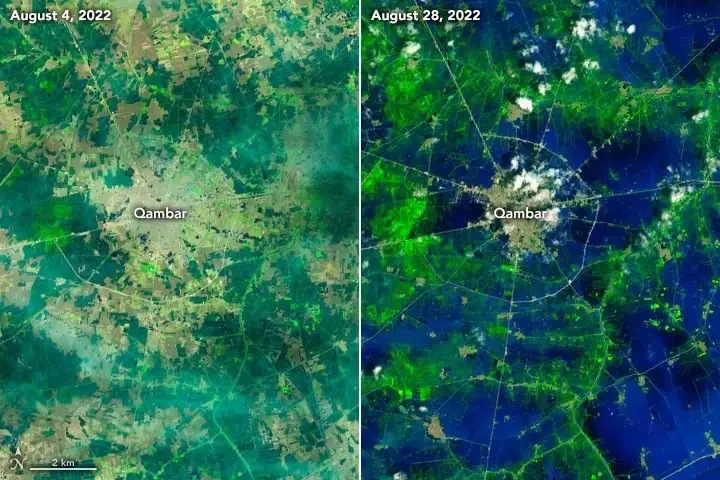
The map
Select the image to view it at full size.
Results
What the analysis delivered
- Automated water maps for each date.
- A flood extent layer showing newly inundated land.
- Flooded area statistics by district.
Key highlights
Why this project stands out
- Machine learning classification
- Fully scripted Python workflow
- Before and after comparison
- Repeatable for new events
Data sources
Data used
- Landsat 8 and 9 imagery before and after flooding
- Training samples for water and land
- District boundaries
Tools and technologies
Software and methods
Deliverables
What the client received
- Flood extent layers
- Python scripts and documentation
- Area statistics
WHY IT MATTERS
Automated flood mapping gives responders a reliable picture within hours of new imagery, helping target relief and assess damage.
FAQ
Questions about this project
Why use machine learning for flood mapping?
It learns how water appears in imagery and adapts better than a single fixed threshold.
Can radar imagery be used?
Yes. Sentinel-1 radar sees through cloud and is often used during floods.
Related projects